
Alberta Regions / Areas Map
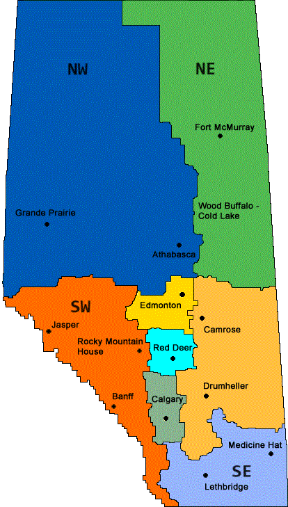
There seems to be no commonly agreed-upon way to organize or subdivide Alberta,
so I've roughly adopted the Indian regions map, as it appears to group areas
by population centers as well as geography.
Yellow = Edmonton area
Light Orange / Tan = Camrose-Drumheller area
Light blue = Red Deer area
Gray = Calgary area
Blue-purple = Southeast Alberta, including Medicine Hat and Lethbridge
Blue = Northwest Alberta, including Grand Prairie and Athabasca
Green = Northeast Alberta, including Fort McMurray
Orange = Southwest Alberta, including Banff, Jasper and Rocky Mountain House
Do you know of any Christmas tree farms or other special Christmas and winter events in Alberta? Please tell me about them - Click here to write to me!
Do you know of any Christmas tree farms or other special Christmas and winter events in Alberta? Please tell me about them - Click here to write to me!
For Easter egg Hunts, Children's Consignment Sales, Local Farm Markets and other types of Farms, click here.
Find Other types of farms:
- Farm markets and roadside stands
- Road trips and camping resources
- Home canning supplies at the best prices on the internet!
- Maple Syrup Farms, sugarworks, maple syrup festivals
- Environmental information and resources
- Consumer fraud and scams information
- Farms For Your Event for birthday parties, weddings, receptions, business meetings, retreats, etc.
- Pick Your Own fruits and vegetable farms
- Festivals - local fruit and vegetable festivals
- Local Honey, apiaries, beekeepers
- Local Meat, Milk and Eggs
Get the
most recent version of
the Ball Blue Book